Fail:Argyle Cut.jpg

Fail asli (1,121 × 795 piksel, saiz fail: 52 KB, jenis MIME: image/jpeg)
Ringkasan
| Keterangan |
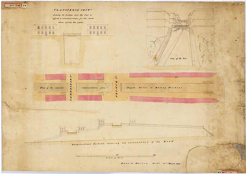
English: Transverse section showing the bridges over the [Argyle] Cut to afford a communication for the streets above, across the same, 22 March 1832
From the Surveyor General's Maps and plans. SRNSW: CGS 13859, [SZ 468]. This plan shows the bridges which were to be built over the Cut when it was completed. Convict labour was employed on the Argyle Cut which was made to give access from Sydney Cove to Miller's Point and Darling Harbour. Before the cut was excavated, pedestrians crossed the ridge by means of steps cut into the sandstone. The marks from the tools used in the operation remain as evidence of this feat of manual labour. The rock and rubble from the excavation was taken several hundred metres away to pack the mouth of the Tank Stream as a sea-wall at Circular Quay. http://www.records.nsw.gov.au/public/gallery/rocks/displays/displays-item-7.html |
| Tarikh | |
| Sumber | http://www.records.nsw.gov.au/public/gallery/rocks/images/items/large/7.jpg |
| Pengarang | From the Surveyor General's Maps and plans |
Perlesenan
This image or other work is of Australian origin and is now in the public domain because its term of copyright has expired. According to the Australian Copyright Council (ACC), ACC Information Sheet G023v19 (Duration of copyright) (January 2019).1
When using this template, please provide information of where the image was first published and who created it. |
 | |||||||||||||||||||
Sejarah fail
Klik pada tarikh/waktu untuk melihat rupa fail tersebut pada waktu itu.
| Tarikh/Waktu | Gambar kenit | Ukuran | Pengguna | Komen | |
|---|---|---|---|---|---|
| semasa | 23:15, 8 Februari 2009 | | 1,121 × 795 (52 KB) | Macr | {{Information |Description={{en|1=Transverse section showing the bridges over the [Argyle] Cut to afford a communication for the streets above, across the same, 22 March 1832 From the Surveyor General's Maps and plans. SRNSW: CGS 13859, [SZ 468]. This p |
Penggunaan fail
Laman berikut menggunakan fail ini:
Penggunaan fail sejagat
Fail ini digunakan oleh wiki-wiki lain yang berikut:
- Penggunaan di en.wiki.x.io
- Penggunaan di ja.wiki.x.io
- Penggunaan di zh.wiki.x.io